
There are 22 ways up Blencathra. But on a day of cloud inversion, Ronald Turnbull has to have Halls Fell. Find out why in this account of the Blencathra (Halls Fell) walk.
These tricky questions came up when a family member, recently retired to cultivate his pumpkins in France, decided to do Blencathra. Was it a good idea, which way to go, and would I like to come too?
The third question was easy. There’s never a day when I don’t want to go up Blencathra. The second isn’t much harder. There are 22 ways up, but for one who’s only going to do it once, the choice is simple: Sharp Edge, or the rather easier Halls Fell ridge?
Would it be fun? We’d find that out when we got there…
Another email whooshed into the inbox. “We are both somewhat sedentary being both retired now, but we are keen to give it a bash – probably not via Sharp Edge though.” Shucks! Someone’s been showing them pictures of Sharp Edge.
I hit reply. “Okay, there’s Halls Fell, pretty straightforward but pleasantly scrambly. T and J [my kids] did it when about 11 and 9, and I did it when about 6, so multiplying those ages together and taking the square root it’s altogether suitable for retired gentlemen taking time off from their marrow bed.”
Halls Fell
Careful camera angles can make Halls Fell almost alpine. But it’s got little paths, and big handholds, and the sides aren’t steep enough to be truly scary. It goes on being not-truly scary for about 300m of height gain; then it arrives like a real ridge should at the very tip top point of the mountain. And as you go up, the ever wider views extend over half of Lakeland.
Well, they would do except the cloud’s down.
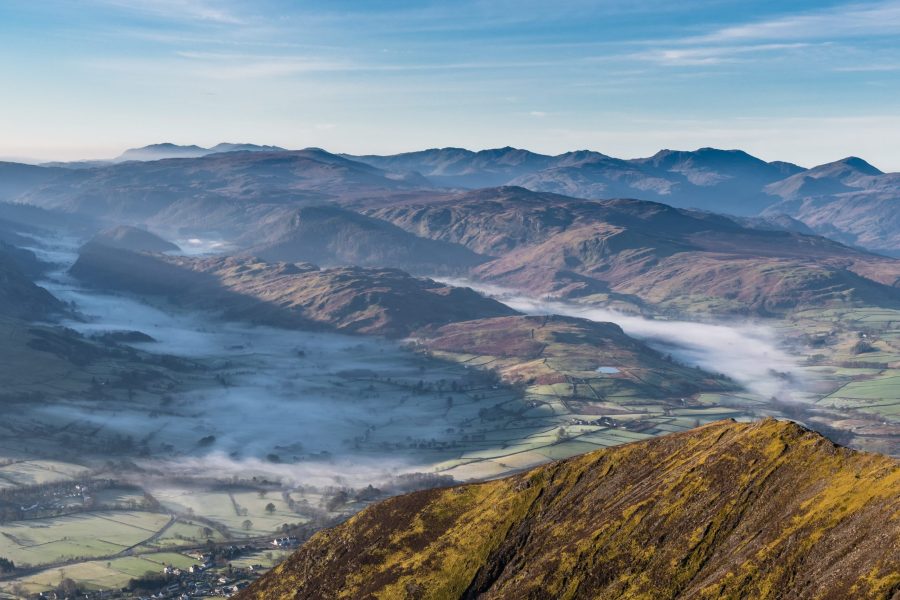
Bob and Spongy (not their real names, come off it, nobody’s called ‘Spongy’) set off at speed from Threlkeld. I was glad I’d chosen the path from the village’s west end, as this gave a relaxing flat bit along the fell wall before the steep lower ridgeline of Halls Fell. We hit the mist; but not long after that, the Halls Fell rocky lumps expanded all romantic, cloud tearing between their not-very-mighty excrescences.
Cloud inversion over Helvellyn
And then the cloud tore apart in holes, and we emerged on top. Away to the south, Helvellyn’s head poked out like someone in a really deep bath of bubble-foam. Well, I’d read the weather forecast, I knew it was going to happen.
“Sorry, but the top’s only 20m above us now.” They didn’t believe me – but that’s Blencathra. We strolled to Gategill Top, cloud lapping against the ridge like walking along a jetty at the seaside. Up in this world of blue and white it was us, and some distant Scafells poking through the cloud-sea, and a dozen others who’d read the small print in the weather forecast.
Chilly weather? Make sure you pack a mid-layer! Here’s our buyer’s guide to fleeces and mid-layers.
There may be two really good ways up Blencathra, but there’s only one way down. We followed the top of Scales Fell, along the tops of some of Blencathra’s really bad ways (Doddick Gill – see Blencathra, page 20 in Wainwright). We dropped to a gloomy and cloudlocked Scales Tarn. Down beside the waterfalls, and the path contoured the high side of Glenderamackin to the sudden col above Mousthwaite Comb.
Head in the clouds on Halls Fell: a day to treasure, through any hail and sleet the rest of the winter may have ahead.

ROUTE DESCRIPTION
- From road junction west of Horse & Farrier, uphill to car park, then path left of stream up to open fell. Turn R along fell wall and after 1km cross Gate Gill stream.
- Take path up spur corner ahead. After levelling, either rocky crest (good holds, well used) or various small paths to right, up to Blencathra summit.
- Wander ridge W to Gategill Fell Top and back.
- Descend E on rebuilt path, and along crestline of Scales Fell until it turns from NE to E and levels; here turn L down grass to Scales Tarn.
- Path follows outflow stream, then contours SE to Mousthwaite col. Small path contours R around Mousthwaite Comb rim, then down to fell wall above Scales.
- Path above fell wall contours S of W, with scrambly bit emerging from Scales Beck, to foot of Halls Fell. Turn down beside stream to E end of Threlkeld.
Header image © Shutterstock
There are 22 ways up Blencathra. But on a day of cloud inversion, Ronald Turnbull has to have Halls Fell. Find out why in this account of the Blencathra (Halls Fell) walk.
These tricky questions came up when a family member, recently retired to cultivate his pumpkins in France, decided to do Blencathra. Was it a good idea, which way to go, and would I like to come too?
The third question was easy. There’s never a day when I don’t want to go up Blencathra. The second isn’t much harder. There are 22 ways up, but for one who’s only going to do it once, the choice is simple: Sharp Edge, or the rather easier Halls Fell ridge?
Would it be fun? We’d find that out when we got there…
Another email whooshed into the inbox. “We are both somewhat sedentary being both retired now, but we are keen to give it a bash – probably not via Sharp Edge though.” Shucks! Someone’s been showing them pictures of Sharp Edge.
I hit reply. “Okay, there’s Halls Fell, pretty straightforward but pleasantly scrambly. T and J [my kids] did it when about 11 and 9, and I did it when about 6, so multiplying those ages together and taking the square root it’s altogether suitable for retired gentlemen taking time off from their marrow bed.”
Halls Fell
Careful camera angles can make Halls Fell almost alpine. But it’s got little paths, and big handholds, and the sides aren’t steep enough to be truly scary. It goes on being not-truly scary for about 300m of height gain; then it arrives like a real ridge should at the very tip top point of the mountain. And as you go up, the ever wider views extend over half of Lakeland.
Well, they would do except the cloud’s down.
Bob and Spongy (not their real names, come off it, nobody’s called ‘Spongy’) set off at speed from Threlkeld. I was glad I’d chosen the path from the village’s west end, as this gave a relaxing flat bit along the fell wall before the steep lower ridgeline of Halls Fell. We hit the mist; but not long after that, the Halls Fell rocky lumps expanded all romantic, cloud tearing between their not-very-mighty excrescences.
Cloud inversion over Helvellyn
And then the cloud tore apart in holes, and we emerged on top. Away to the south, Helvellyn’s head poked out like someone in a really deep bath of bubble-foam. Well, I’d read the weather forecast, I knew it was going to happen.
“Sorry, but the top’s only 20m above us now.” They didn’t believe me – but that’s Blencathra. We strolled to Gategill Top, cloud lapping against the ridge like walking along a jetty at the seaside. Up in this world of blue and white it was us, and some distant Scafells poking through the cloud-sea, and a dozen others who’d read the small print in the weather forecast.
Chilly weather? Make sure you pack a mid-layer! Here’s our buyer’s guide to fleeces and mid-layers.
There may be two really good ways up Blencathra, but there’s only one way down. We followed the top of Scales Fell, along the tops of some of Blencathra’s really bad ways (Doddick Gill – see Blencathra, page 20 in Wainwright). We dropped to a gloomy and cloudlocked Scales Tarn. Down beside the waterfalls, and the path contoured the high side of Glenderamackin to the sudden col above Mousthwaite Comb.
Head in the clouds on Halls Fell: a day to treasure, through any hail and sleet the rest of the winter may have ahead.
ROUTE DESCRIPTION
- From road junction west of Horse & Farrier, uphill to car park, then path left of stream up to open fell. Turn R along fell wall and after 1km cross Gate Gill stream.
- Take path up spur corner ahead. After levelling, either rocky crest (good holds, well used) or various small paths to right, up to Blencathra summit.
- Wander ridge W to Gategill Fell Top and back.
- Descend E on rebuilt path, and along crestline of Scales Fell until it turns from NE to E and levels; here turn L down grass to Scales Tarn.
- Path follows outflow stream, then contours SE to Mousthwaite col. Small path contours R around Mousthwaite Comb rim, then down to fell wall above Scales.
- Path above fell wall contours S of W, with scrambly bit emerging from Scales Beck, to foot of Halls Fell. Turn down beside stream to E end of Threlkeld.
Header image © Shutterstock


