

Vivienne Crow heads up Bulbeck Common for a moorland wande
The pretty conservation village of Blanchland, close to Northumberland’s border with County Durham, sits in a woody hollow just west of Derwent Reservoir. It was established in 1169 when Premonstratensian monks founded an abbey here. Clad in robes made from undyed sheep’s fleeces, they were known as the ‘white canons’ – hence the village name, meaning ‘white land’.
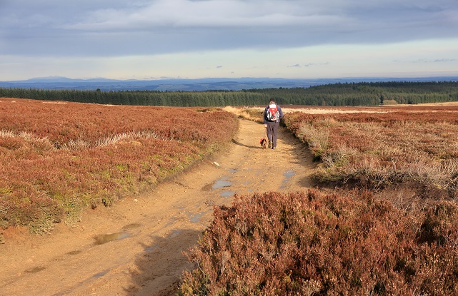
It was a grey morning as we set off from the village car park. A series of cold, heavy showers had just passed and more persistent rain was forecast for the afternoon. We were hoping to complete our short walk before the wet stuff moved in. A good track provided us with easy-going to the moorland edge, past the cottages at Shildon and the 200-year-old, Cornish-style lead mine engine house.
There was no mistaking the dominant bird species when we finally reached the heather: the reddish-brown heads of the grouse bobbed up and down, well camouflaged except for the red eye combs that gave them away. And, just when we’d least expect it, just when we were enjoying the peace and quiet of the wide, open spaces, they would jump out of their hiding places with a battering of wings and that mocking cackle they make, scaring the living daylights out of us.
The climb was barely noticeable; it was really only as the views opened out that we had any sense of having gained height, albeit barely a couple of hundred metres. It was hard to believe, as we gazed into the distance, that the highest point on this track was less than 400m above sea level.
Crowned by a small clump of clouds, a dark grey group of hills stood out clearly to the north. Unable to reconcile this sight with what my internal map was telling me – that we were looking at the Cheviots – I stood and carefully worked out what else this might be. My conclusion? It was the Cheviots, about 40 miles away, but looking like they were no more than 10 miles distant. The air was that clear!
We dropped to the edge of Slaley Forest, only briefly flirting with this sprawling plantation before we picked up another excellent bridleway on the western edge of the high ground. This is the Carriers’ Way, a packhorse route used in the 18th century to carry smelted lead to the River Tyne. With little to worry about underfoot and not much in the way of ascent or descent, this was moorland walking at its best: a perfect opportunity to set my focus on the distance again. This time, it was to the west I looked: on the other side of the valley carved by Devil’s Water was a patchwork of pale green fields topped by the brown uplands of Hexhamshire Common. Here lies an even larger expanse of moorland, even bigger skies, higher ground and, possibly, better views. Sounds tempting! Maybe I’ll head up there next time I’m in the area…
ROUTE DESCRIPTION
- Turn L out of car park. As track swings R near Pennypie House, go through large gate on L.
- Keep to broad track beside wall. After gate, head uphill on clear track. Nearing edge of Slaley Forest, keep R at fork along clearer track.
- This enters Forestry Commission land via large gate. Take next turning on L. About 400m after passing track to R, turn L on faint path.
- Go through gate in forest fence and turn L, beside fence. At next gate, turn R along narrow trail, close to fence on L. This joins bridleway coming in from R. Go straight across one track close to metal hut.
- About 0.5km after a gate in a wall, bear L at waymarked fork. Follow waymarkers across damp, peaty ground. Path becomes more obvious after next gate.
- On rwaching point at which a fence meets a wall, go through gate in fence. Walk beside wall on R. At far end of this enclosure, go through gate on L. Follow wall round to R. Follow lane downhill.
- Turn L through gate on sharp right-hand bend and cross field paths.
- Turn R along wide track. Turn R at next junction to return to car park.

Vivienne Crow heads up Bulbeck Common for a moorland wande
The pretty conservation village of Blanchland, close to Northumberland’s border with County Durham, sits in a woody hollow just west of Derwent Reservoir. It was established in 1169 when Premonstratensian monks founded an abbey here. Clad in robes made from undyed sheep’s fleeces, they were known as the ‘white canons’ – hence the village name, meaning ‘white land’.
It was a grey morning as we set off from the village car park. A series of cold, heavy showers had just passed and more persistent rain was forecast for the afternoon. We were hoping to complete our short walk before the wet stuff moved in. A good track provided us with easy-going to the moorland edge, past the cottages at Shildon and the 200-year-old, Cornish-style lead mine engine house.
There was no mistaking the dominant bird species when we finally reached the heather: the reddish-brown heads of the grouse bobbed up and down, well camouflaged except for the red eye combs that gave them away. And, just when we’d least expect it, just when we were enjoying the peace and quiet of the wide, open spaces, they would jump out of their hiding places with a battering of wings and that mocking cackle they make, scaring the living daylights out of us.
The climb was barely noticeable; it was really only as the views opened out that we had any sense of having gained height, albeit barely a couple of hundred metres. It was hard to believe, as we gazed into the distance, that the highest point on this track was less than 400m above sea level.
Crowned by a small clump of clouds, a dark grey group of hills stood out clearly to the north. Unable to reconcile this sight with what my internal map was telling me – that we were looking at the Cheviots – I stood and carefully worked out what else this might be. My conclusion? It was the Cheviots, about 40 miles away, but looking like they were no more than 10 miles distant. The air was that clear!
We dropped to the edge of Slaley Forest, only briefly flirting with this sprawling plantation before we picked up another excellent bridleway on the western edge of the high ground. This is the Carriers’ Way, a packhorse route used in the 18th century to carry smelted lead to the River Tyne. With little to worry about underfoot and not much in the way of ascent or descent, this was moorland walking at its best: a perfect opportunity to set my focus on the distance again. This time, it was to the west I looked: on the other side of the valley carved by Devil’s Water was a patchwork of pale green fields topped by the brown uplands of Hexhamshire Common. Here lies an even larger expanse of moorland, even bigger skies, higher ground and, possibly, better views. Sounds tempting! Maybe I’ll head up there next time I’m in the area…
ROUTE DESCRIPTION
- Turn L out of car park. As track swings R near Pennypie House, go through large gate on L.
- Keep to broad track beside wall. After gate, head uphill on clear track. Nearing edge of Slaley Forest, keep R at fork along clearer track.
- This enters Forestry Commission land via large gate. Take next turning on L. About 400m after passing track to R, turn L on faint path.
- Go through gate in forest fence and turn L, beside fence. At next gate, turn R along narrow trail, close to fence on L. This joins bridleway coming in from R. Go straight across one track close to metal hut.
- About 0.5km after a gate in a wall, bear L at waymarked fork. Follow waymarkers across damp, peaty ground. Path becomes more obvious after next gate.
- On rwaching point at which a fence meets a wall, go through gate in fence. Walk beside wall on R. At far end of this enclosure, go through gate on L. Follow wall round to R. Follow lane downhill.
- Turn L through gate on sharp right-hand bend and cross field paths.
- Turn R along wide track. Turn R at next junction to return to car park.


