
Advertisement
Snowdon via the Miner’s Track
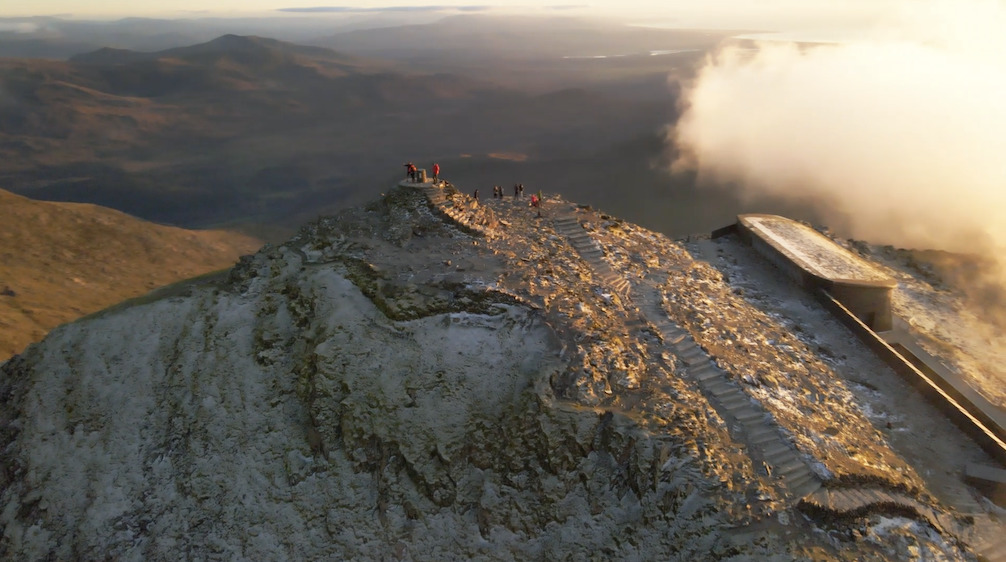
Drone footage from the sunset from the summit of Snowdon, taken from our hyperlapse film
The Miner’s Track is one of the shortest routes to the summit of Snowdon / Yr Wyddfa – but it’s not to be underestimated. Here’s our detailed description and accompanying hyperlapse film.
The highest mountain in Wales has a magnetic appeal, drawing walkers and visitors from far and wide. Its popularity is deserved: this is one of the most architecturally magnificent mountains in Britain, with a host of airy ridges radiating out from a magnificent pyramidal summit.
The Miner’s Track is one of the shortest of the main walking routes to the summit of Snowdon / Yr Wyddfa. Like the Pyg Track, which it eventually joins up with, the Miner’s Track starts at Pen y Pass, which effectively means a 350 metre ‘leg up’ to the summit before you’ve even started walking.
However, the Miner’s Track is still a challenging undertaking, involving 5 – 6 hours of walking there and back, 750 metres of ascent, a steep and rocky climb from Glaslyn to Bwlch Glas, and areas of loose and jumbled terrain where it can be easy to wander off-route (the Welsh government-sponsored Adventure Smart website has some great general safety guidance on hiking in Wales, and specific advice on the Miner’s Track.)
In winter, the top of this section can often be covered in snow, even when much of the rest of the mountain is snow-free, requiring the use of ice axe and crampons and knowledge of how to use them (a winter skills course run by the centres like Plas y Brenin or Glenmore Lodge is a good place to get this knowledge).
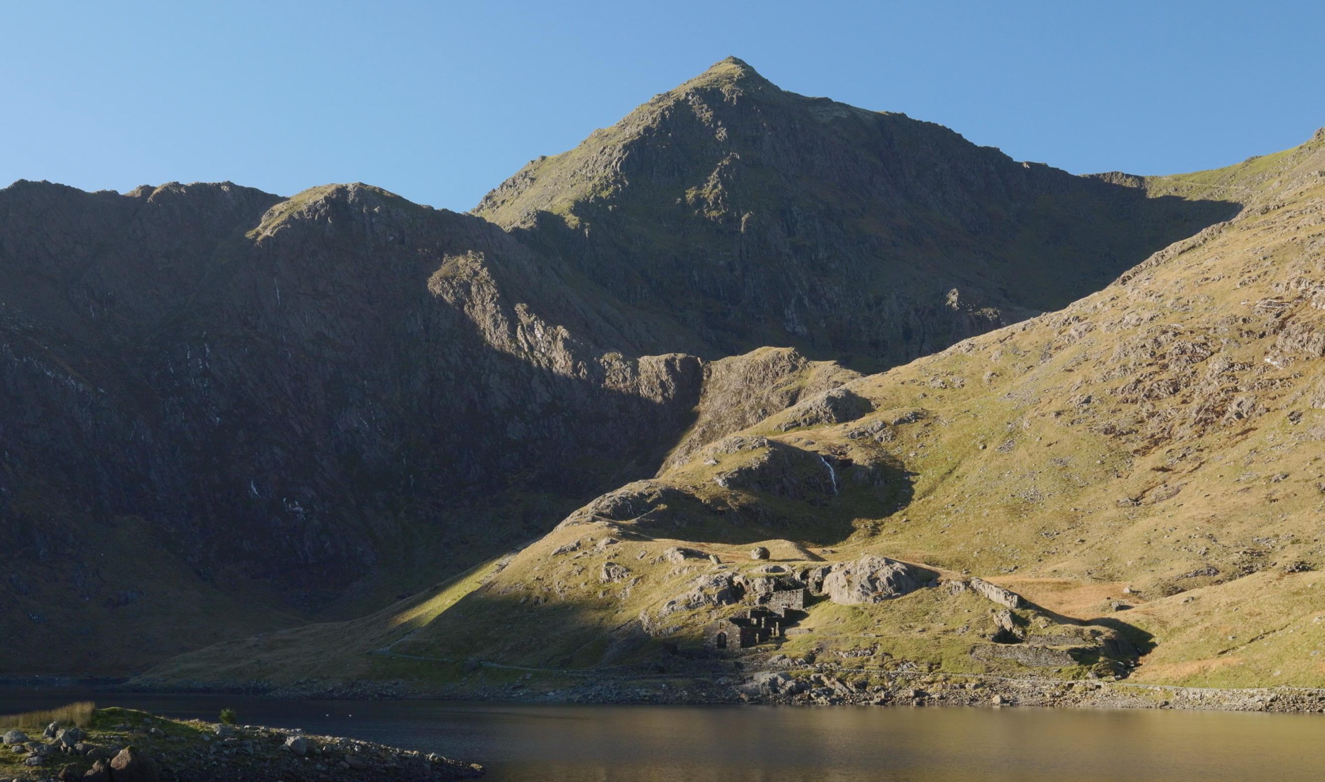
But it’s worth the effort: this is a classic route for a reason, taking you past a pair of beautiful glacial lakes, and slowly revealing the grandeur of the Snowdon massif as you climb. You also pass remains of the Britannia Copper Mine, which the route was originally built to serve.
Snowdon is a crowd-magnet, attracting more annual visitors than any other mountain in the UK, and the comparatively short length and accessibility of the Miner’s Track means it is one of the most popular routes to its summit. Most of the time you can expect to be sharing this route with others – and if it happens to be a sunny Bank Holiday, for example, expect to be sharing it with lots of others. Even a super-early morning start doesn’t necessarily guarantee solitude, as the route can see bleary-eyed Three Peaks Challengers hiking up it at that time.
All of which is no problem if you’re happy to embrace the sociable vibe, but if you’re looking for a lesser-trodden walking route up Snowdon, the Watkin, Snowdon Ranger or Rhydd Du paths may be better bets (or you could combine the Miner’s Track with one of these routes to form a linear traverse, and use the Snowdon Sherpa bus to get back to your start.)
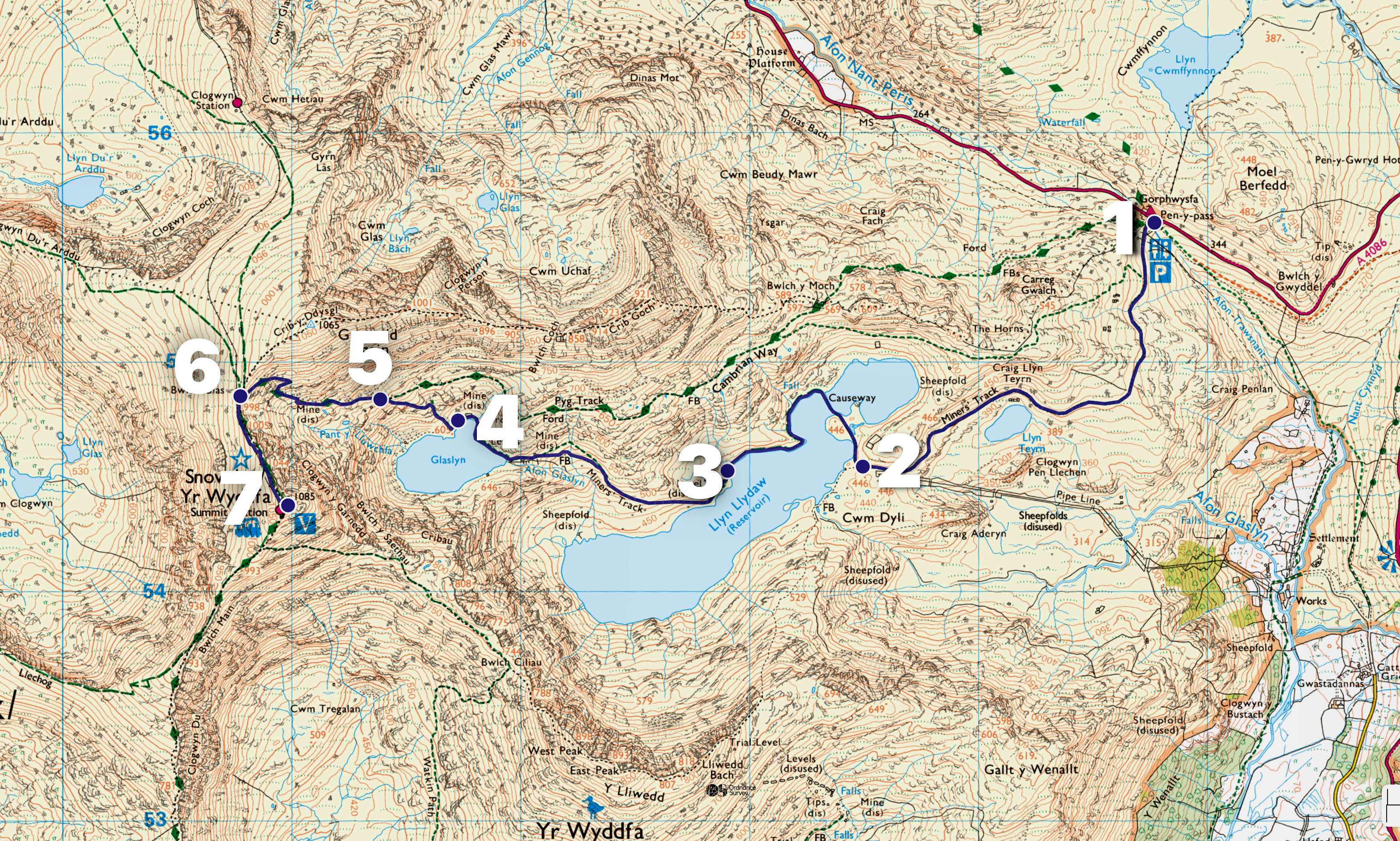
START/FINISH: Pen y Pass car par (GR: SH647556)
MAPS: OS Explorer OL17 1:25,000 (Snowdon and Conwy Valley), OS Landranger 115 1:50,000 (Snowdon / Yr Wyddfa), Harvey Superwalker 1:25,000 (Snowdonia North)
DISTANCE: 13km/8 miles
ASCENT: 764m/2506ft
DURATION: 5 – 6 hours
PARKING AND TRANSPORT: The Pen y Pass car park, but availability is limited and very early arrival is needed to get a space. The Park and Ride bus between Nant Peris and Pen y Pass takes just 10 minutes though – check out the timetable here (S1 / S2 / S5 buses).
ROUTE DESCRIPTION
1. Start (Grid reference: SH647556)
Find the entrance to the Miner’s Track in the far-left corner of the Pen y Pass car park, waymarked with a stone, pass through the gate, and follow the clear track for around 2km, passing Llyn Teryn.
2. Intersection with Y Liwedd path (SH634545)
Close to the shore of Llyn Llydaw, a path branches off towards Y Lliwedd, but continue following the wide Miner’s Track as it swings to the right and over the causeway across Llyn Llydaw. Keep following the track as it passes along the shore of Llyn Llydaw and the remains of the Britannia Copper Mine.
3. Ascending from Llyn Llydaw (SH628643)
Follow the path as it leaves the shore of Llyn Llydaw and begins ascending, then skirts around the shore of Glaslyn.
4. Ascent from Glaslyn (SH617547)
Follow the defined path as it climbs steeply up through a rocky and somewhat jumbled section (don’t be tempted to keep following the less well-defined path around the shore of Glaslyn). The route can be a little tricky to follow in places during this section, so be sure to keep to the stone-pitched path.
5. Intersection with the Pyg Track (SH614548)
The Miner’s Track intersects with the Pyg Track at this point. Keep following the path upwards – again taking care to stay on the path amidst the rocky surroundings – and climb through the zig-zags to reach Bwlch Glas.
6. Bwlch Glas (SH607548)
At Bwlch Glas – the gap in the ridge between Garnedd Ugain and Snowdon’s Summit – turn left, and follow theridge south and upwards towards the summit of Snowdon.
7. Snowdon summit (SH610543)
Admire the view from Snowdon’s summit (if there is one!) – although you may well be sharing it with others, and queues for the very top often form! Retrace your steps downwards back to Pen y Pass – but take care at the intersection of the Miner’s Track and the Pyg Track, as it can be easy to end up on the latter by mistake when descending, particularly in poor visibility (although it also leads back to Pen y Pass).
©Crown copyright 2022 Ordnance Survey. Media 051/19’
