
How to read a compass – because everyone needs a reminder!
Learning how to use a compass is an important outdoor skill; not just for walkers, but cyclists and runners too. It’s good to take a compass with you, but even better if you know what to do with it.
Our guide to using a compass gives you the basic skills, hopefully without over-complicating things.
There are also videos below by Simon King on ‘Know your compass’, and ‘How to use a compass’, and a further short film by Graham Thompson of Trail Magazine to show you how.
Why do you need a compass?
A compass helps you to find where you are and find your way; this is very useful but can be critical if you get lost and visibility is poor. The main ways you use a compass are:
- ‘Setting’ the map with the compass so that it matches what you see on the ground, and that you’re pointing in the right direction.
- Taking a bearing from the map and walking on a bearing (direction)
- Using a bearing to identify features on the ground by checking the bearing from where you are.
- Identifying your own position using ‘back bearings’ from two or more distant known features (also known as ‘resectioning’).
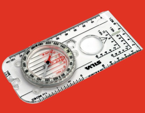
Compass features
Compasses come in many designs, but most compass features are the same as those found in an all-time classic compass like the Silva Ranger. You need to make use of some or all of the compass features for different tasks.
Before you can use a compass to navigate you need to be familiar with the main features.
- Baseplate – the plastic base.
- Compass housing – also known as the compass wheel, with a mark every two degrees covering 360 degrees, and N-S-E-W (the ‘cardinal points’).
- Magnetic needle – red end for north, white for south.
- Compass lines – on the bottom of the baseplate (also called ‘orienting lines’.
- Orienting arrow – fixed and aligned to north within the compass housing
- Index line – extension of the direction of travel arrow.
- Direction of travel arrow – the big arrow at the end of the baseplate.
- Map scales 1:25 000, 1:50 000 and metric measurer (known as Romer scales).
The main working part of a compass is the magnetic ‘needle’ that floats on a central pivot. The red end always points to the Earth’s magnetic north pole and the outer ring is marked with the cardinal points of the compass (N-S-E-W) and every 2 degrees. These markings are used to get bearings (the direction from where you are, to where you want to go).
If you rotate the ring to line-up the red north of the needle to the red arrow on the baseplate, a bearing can be be taken from the compass ring.
Where is north?
There is, however, a slight complication; magnetic north is not the same as map grid north because magnetic north (where the compass needle points) changes in different areas of the world, and also changes over time.
To get a completely accurate reading you have to adjust the bearing to take account of the difference between map grid north and magnetic north. The degree of deviation is marked on printed Ordnance Survey maps but as a rough guide, you should adjust by 2 degrees by turning the compass housing anticlockwise. For longer trips, the difference can have a significant impact on navigation.
There is more information on the Ordnance Survey website
For online maps, see Ordnance Survey’s Get-a-map service


