
‘Dangerous’ routes which led to two rescues in the Lake District are visible on many popular navigation apps, leading outdoor experts to call for apps to make more careful use of digital mapping data.
The rescues last week both saw walkers get into difficulty after following routes on the AllTrails app which led over steep or hazardous terrain.
The episode led to criticism of AllTrails, but the routes in question were also visible on other major navigation apps aimed at walkers, such as OS Maps, the Ordnance Survey’s own mapping app, as well as Outdooractive, MapOut and Komoot.
The episode has shed a light on how the apps use and present the underlying data which they all draw from – the open source, volunteer-maintained OpenStreetMap (OSM).
Outdoor experts and mountain rescuers have called for more awareness of the role of this volunteer-maintained data. They have also called for apps to incorporate better moderation and improved visual design to make the difficulty level of routes clearer to users.
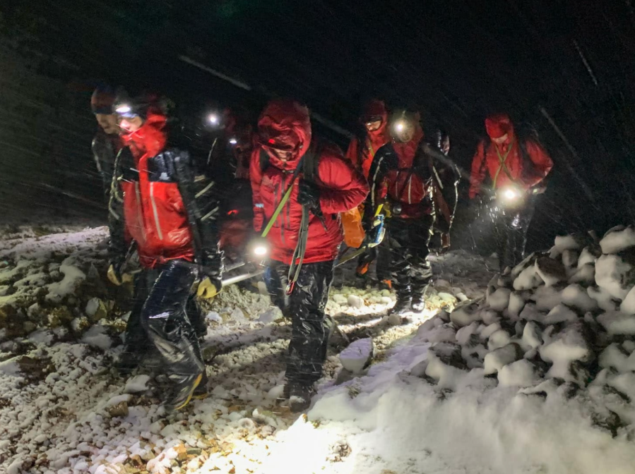
Main image: A call out on January 1st 2023 on Green Gable with the RAF and Keswick MRTs | Credit: KMRT
‘Free wiki world map’
OSM describes itself as the ‘free wiki world map’. Like Wikipedia, it is crowdsourced, maintained by a global community of volunteers. According to its website it “provides map data for thousands of websites, mobile apps, and hardware devices.”
Outdoor writer, editor and tech expert Alex Roddie said: “When you follow a walk on an app, it’s presented as something you can follow safely, and there is no obvious reason to doubt it. In everyday life, we are used to apps being reliable and rarely have cause to doubt what we’re seeing. It’s rare, for example, that Google Maps shows a street that isn’t there, but mapping a mountain isn’t the same as mapping a city, and I don’t think it’s widely enough known that many of these apps rely on voluntary mapping contributions.”
One of the ‘paths’ which led to a rescue last week was on the south-east ridge of Barf Fell, above Bassenthwaite. A spokesperson for Keswick Mountain Rescue Team, which carried out the rescues, said: “There is no path via this route – only a scramble of loose scree which also requires the walker to negotiate the rocky outcrop of Slape Crag. It’s the scene of previous callouts.”
The screengrabs below show that this route was visible across various different popular apps which use OSM data in some form.
AllTrails shows the route – highlighted in the screenshot as ‘Slape Crag route’ – on its main ‘AllTrails’ layer.

OS Maps showed the route on its free ‘Standard’ layer (users can purchase Ordnance Survey Explorer or Landranger mapping in the app, which does not show the route). The route has since been deleted on the app.
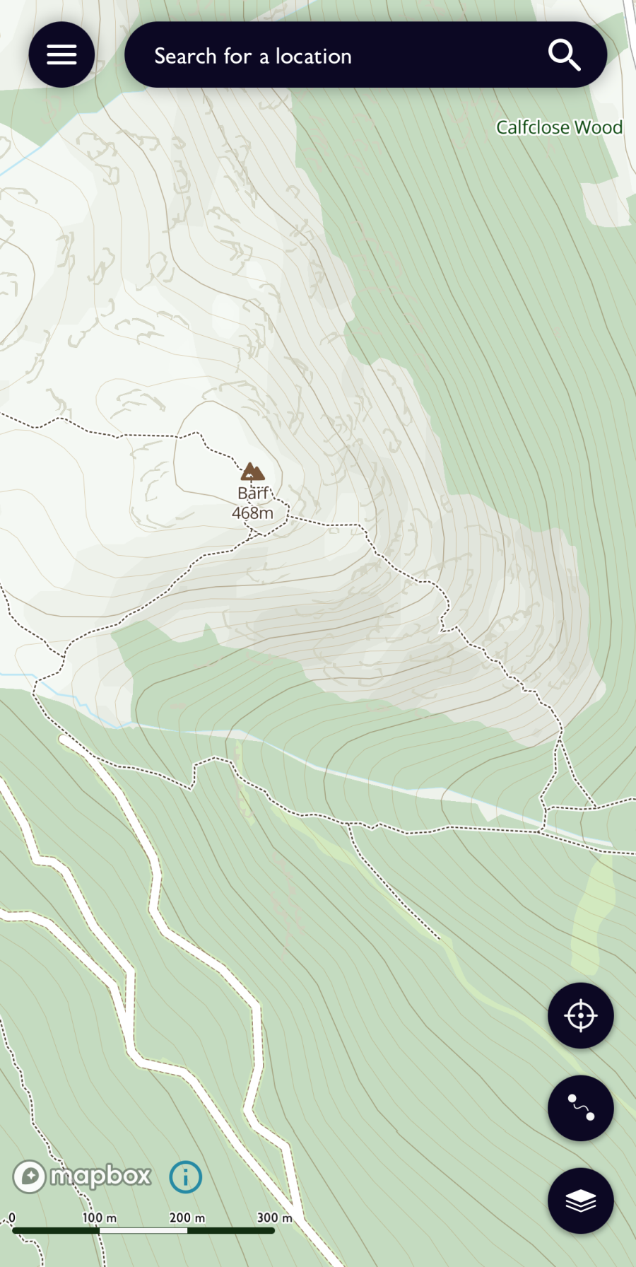
Outdooractive shows the route on its free ‘Outdooractive’ layer (users can purchase Ordnance Survey Explorer or Landranger mapping in the app, which does not show the route, or Harvey mapping, which also does not show the route)
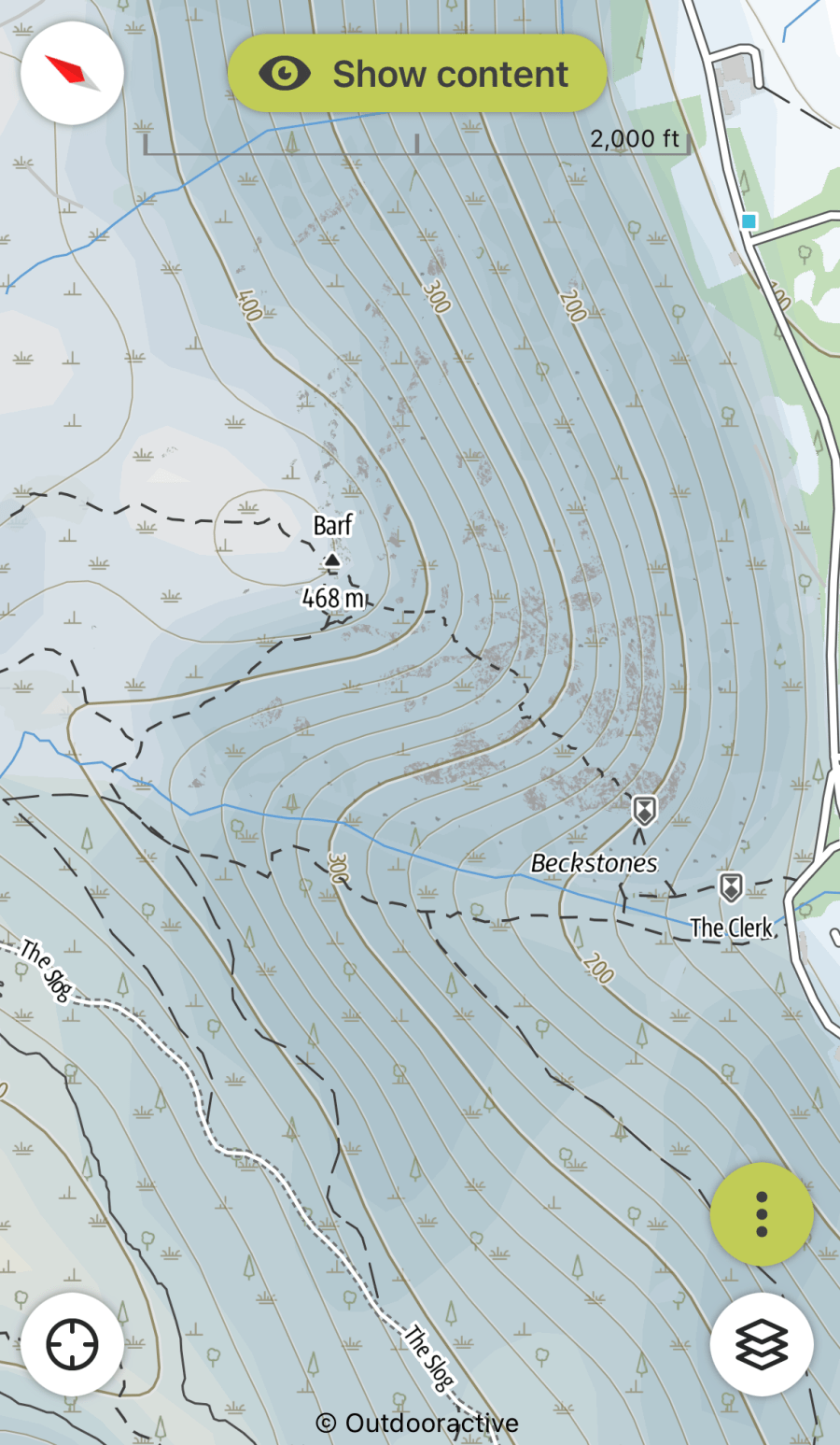
Komoot shows the route on its main layer, albeit with dotted and dashed lines to indicate that the path has a higher difficulty level.
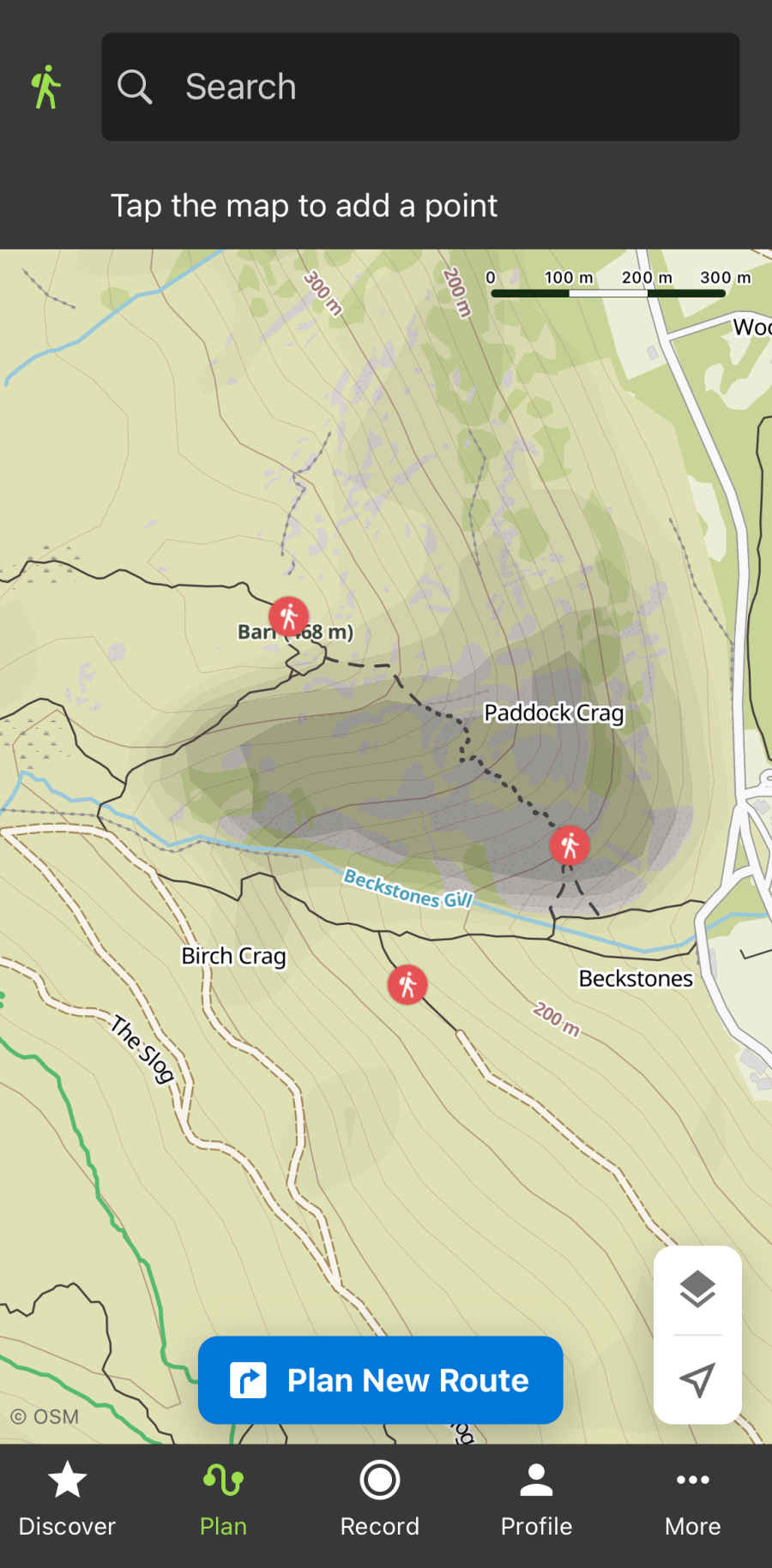
As the screenshots show, although the different apps featured above all include the path, they present it in different ways.
OSM data grades each path with a SAC Mountain and Alpine Hiking Scale which grades the difficulty of paths on a scale of 1 to 6. The Slape Crag route was graded ‘T3 – Difficult mountain hiking’. But mapping apps do not always make this difficulty grade visually apparent to users in the way the paths are presented.
Alex Roddie says: “In apps which use OSM data, there is often no quick and easy way to tell how difficult a user-added trail is. Most apps render them as simple dotted or dashed lines – even technical scrambling routes have little or no differentiation.
“In the Alps, some apps will show a T grade on the route if you zoom in far enough. However, not every app includes this information (and it isn’t obvious even when present). Some apps use more obscure terminology such as 0.1, 0.2, 0.3, which may or may not mean anything to the user (and this text is often only visible when zoomed a long way in, and there often isn’t a map key).”
Design and moderation
Alex continued: “The problem arises when paths on the OSM data set are either inaccurate or just plain wrong – or when the user misinterprets the information. Recently, Keswick Mountain Rescue Team attended two callouts linked to the OSM-based hiking app AllTrails.
“In one, a benighted walker had attempted a shortcut shown on the map and got lost in the dark; in the other, a walker following a route on the app found it far more difficult than expected and became cragfast. In both cases the trail was clearly marked in the OSM data, but the difficulty (or visibility on the ground) was hard to tell from the app. In both cases no trail was marked on the traditional Ordnance Survey mapping [Explorer and Landranger] – but, confusingly, the trail in question was also visible in the free basic map on the OS Maps app (which uses OSM data).
“I would like to see more visual differentiation between routes of varying steepness and difficulty. I’d also like to see more robust curation and moderation when new routes are added.”
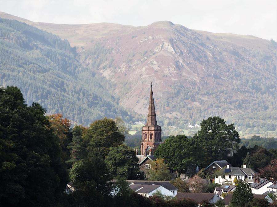
A long-range shot of Keswick showing the south-east ridge of Barf behind, where one of the rescues took place. The route marked on the OSM maps takes walkers over the prominent Slape Crag, which can be seen on the ridge. Photo: Simon Cole / Alamy
Craig Dring, of Keswick Mountain Rescue Team, also expressed concerns to The Great Outdoors about the way OSM data is presented, and called for more verification of the information.
“The use of mapping software on phones is becoming a lot more prevalent by the public, but I don’t think people are widely aware of the use of OSM information by apps. This is the first time we’ve become aware of it as a safety issue.
“I went on the OSM website to comment on the Barf path. I asked them to take it down but their contributors came back and said no, because they put a risk-rating on it, showing that it’s only for experienced walkers, and they’ve said the Strava heat maps suggest a lot of people go up it.
“On the Causey Pike rescue, the day before the Barf rescue, the guy who got into trouble was new to the Lake District. I know that area fairly well, so I know there’s no obvious path where he was. But he didn’t have that knowledge. He was bang on the dotted line on the app but he couldn’t find the path on the ground. The reason it’s there on the OSM data is that it forms part of the Abraham’s Tea Round run – and is also on the Strava heat map. So experienced runners may be OK, but there is not a proper path formed.
“I understand that OSM give difficulty ratings for paths, but the mapping software companies have a responsibility to flag that clearly to their users. Somebody’s got to take some responsibility somewhere. Either the OSM community or the software companies have a responsibility to verify that data.”
OSM response
A spokesperson for the Cambridge-based OpenStreetMap Foundation, the non-profit foundation which supports OSM, told The Great Outdoors: “OpenStreetMap is the result of a team effort by hundreds of thousands of people around the globe. Our guidelines for contributions are that they be truthful, representing real features in the world; legal, based on legally shareable sources and knowledge; verifiable, so that others can go and check the map for themselves; and relevant, sharing features that are clear for re-use.
“The main consideration is what we call the “on the ground rule”: map the world as it can be observed by someone physically there.
“Anyone can sign up and contribute to OSM. People everywhere are experts on the place they come from. We encourage new mappers to learn and connect with other mappers. The community monitors, reviews, and debates changes as they happen to ensure the map reflects what’s in the world.
“OSM is the best global dataset for hiking and outdoors. It is updated by people… who enjoy the outdoors and want to have good maps to use on their own hikes. In many places, for hiking, we are more complete, more up-to-date and more accurate than any other map.
“Details of all edits in OSM are publicly available to analyse. For the [Slape Crag route], the history is available online here. It appears this path was originally surveyed on foot. It also appears in online hiking guides for the area, and on the Strava heat map albeit in less bright colours as the neighbouring paths.
“This path has been marked as difficult since it was added to OSM 10 years ago, with the SAC Scale. It sounds like AllTrails doesn’t consider the SAC scale in OpenStreetMap data, or doesn’t warn its users when they go over a difficult path.
“OSM is used for both the visual base map images, and for navigating on interactive routes. Every app has a different data consumption pipeline and timeline. The data can be imported immediately, but more often, it is processed on some sort of schedule (from daily, to weekly, to monthly and longer). Data consumers often apply both automated and manual quality checks.”
Asked if the Lake District rescues had prompted any thinking within the OSM community about how its data could be better presented in order to avoid more similar situations, the spokesperson said: “The reason the community already maps the trails in detail, including the SAC scale, is to help prevent such situations.
“The OSM community would like to work closer with apps that use our data so that they can better understand how to expose all the details of what we collect, like trail difficulty and access. The OpenStreetMap Foundation is ready to facilitate these connections. Elsewhere, our USA local chapter OpenStreetMap US has been organising a local working group on trail stewardship.
“In the case of the Lake District, it is not the fault of the map that the trail exists. Deleting it from the map would simply result in someone else mapping it again down the line. If it is a dangerous path, it should be signposted.”
Wide range of skills
Craig Dring stressed that hikers in the hills and mountains should always be equipped with a wide range of navigational skills, as well as the highest possible quality topographic mapping.
“Digital mapping is a useful tool in amidst other tools. But if you’re using it in the hills and mountains, we’d aways say you need a high quality Ordnance Survey map like the 1:25,000 Explorer, or a similar quality like Harvey. OSM-based maps just don’t have the same level of topographic detail. I’d happily use them to get ideas, but I wouldn’t rely on them to navigate. It might be OK when it’s nice and sunny, but when it gets gnarly or dark you want more robust information to base your decisions on.”
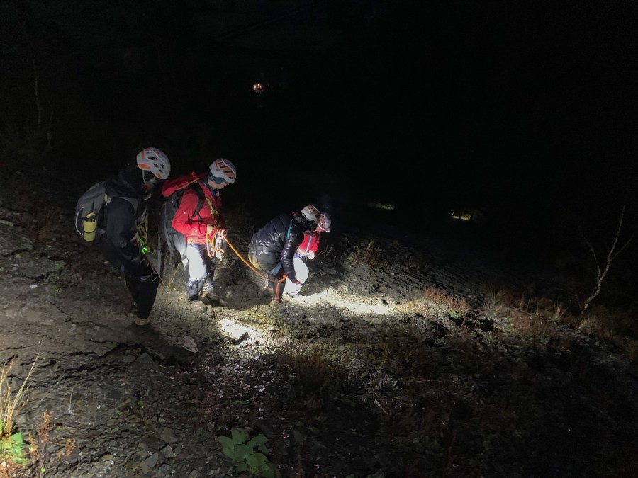
Keswick Mountain Rescue Team members during the Barf rescue. Credit: KMRT
A spokesperson for Ordnance Survey (OS) told The Great Outdoors: “At OS we are passionate about making the outdoors enjoyable, accessible and safe. We would urge anyone looking to get outside to ensure that they have both the right kit and accurate and detailed maps for the environment and conditions.
“OS offers detailed mapping at 1:25,000 and 1:50,000 scale with our OS Explorer and OS Landranger range of paper maps and within the premium subscription to OS Maps app. With that subscription OS users also have access to other features including route mapping, 3D mapping and AR tools.
“We also provide a free version of OS Maps which is ideal for people looking to explore more urban and developed areas rather than adventurous walks and venturing off the beaten track which requires the detailed mapping available within the premium subscription.
“Our team work continuously to ensure the OS mapping is kept up to date with changes and variations to walking routes to support getting outside safely.
“The Open Street Map data was added to OS Maps in 2020 to provide a consistent standard map base for the world supporting OS Maps expansion into new countries. Our developers have removed the route from the Open Street Map data in the app”.
Route warnings


