
Ray Wood enjoys his first taste of bikepacking on a trans-Cambrian adventure
The sight of touring bikes with their often-colourful panniers has always struck a romantic chord with me. It’s that notion of journeying, self-reliance and simple routine. But as a mountain biker and hillwalker, I’d always thought it would be even better if touring took you away from the tarmac and let you really get away from it all. Bikepacking, or off-road touring, lets you do just that.
This wheeled equivalent of a multi-day walk had been on my bucket list for quite some time, but the problem with lists is remembering to look at them. I’d even chosen a route for my first bikepacking trip: the Trans Cambrian Way. It’s not so far from home but would give me the opportunity to explore parts of Wales I’d never visited before. It was just a matter of getting around to it: inertia is a terrible thing.
Over the last couple of years bikepacking has seen a surge in popularity, tied in to the availability of lightweight camping equipment and the development of bikepacking luggage by companies such as Alpkit and Wildcat – suitable for use even on a full-suspension mountain bike. Every mention of bikepacking on social media was a dig in the ribs that I needed to get myself organised.
100 miles across the Elenydd
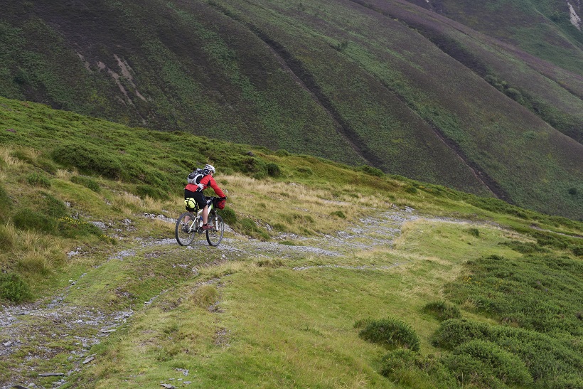
The Trans Cambrian Way is around 100 miles long with 12,000 feet of ascent, starting in the market town of Knighton and finishing by the sea at Dovey Junction. Following bridleways and other rights of way linked by country lanes, it crosses the high and remote moorland of the Elenydd, the central portion of the sparsely populated Cambrian Mountains – once described as the “Green Desert of Wales”. The route isn’t widely known or promoted, and it’s not waymarked, apart from the very occasional yellow arrow, although in places it does follow a national trail: Glyndwr’s Way.
Having chosen to just take a bundle of A4 paper OS 1:50,000 map print-outs with the route marked, navigating was time consuming and not always straight-forward. You can cover a lot of distance on a bike before you realise you’ve made a wrong turn. Using a GPS would be more convenient and easier, but the trip was also supposed to be a break from screens. The phone only came out once and that was just to confirm our position. The Trans Cambria ride is normally done in three days, if you’re reasonably bike fit, stopping overnight in bed and breakfast accommodation. Camping obviously means carrying more weight but it gives you the freedom to choose, within reason, where to stop and adds to the experience in a good way.
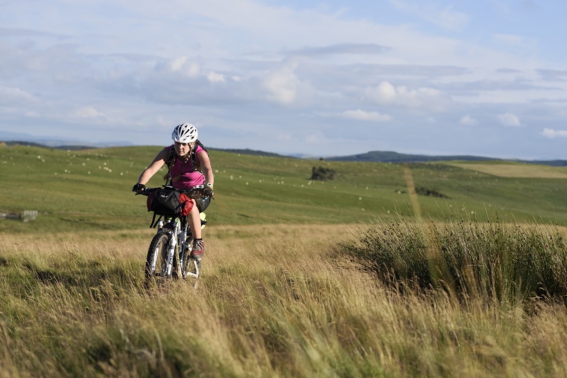
Rachael, who enthusiastically signed up for the adventure, had never done any bikepacking before either. We decided to keep the pressure off and to opt for a ‘leisurely’ four-day itinerary. Parking the car by Knighton railway station we waited for the drizzle to stop. Although the station is in Shropshire, the town centre, a couple of hundred yards away, is in Wales. Surprisingly, the bikes didn’t feel too unwieldy as we pedalled off with fresh legs up the High Street. Travelling east to west means that, although the wind may be against you, there is less ascent this way round.
Arriving at Lloyney after a few kilometres of back lanes, we were surprised to discover that a small nondescript muddy path, cutting steeply up through the woods, was our route up into the hills. Pushing the bikes for a short distance, until the angle eased, we gained a long grassy ridge used in times gone by to connect Knighton and Newtown.
The route then meandered relatively easily and quickly through the heather past Beacon and Warren Hill. Even so, by mid-afternoon the community shop in Llanbadarn Fynydd village was a welcome sight and the chance for a good rest. It was the best stocked village shop I’d ever seen and it even served tea and coffee.
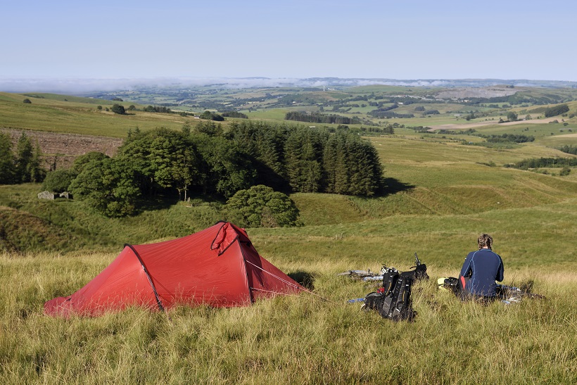
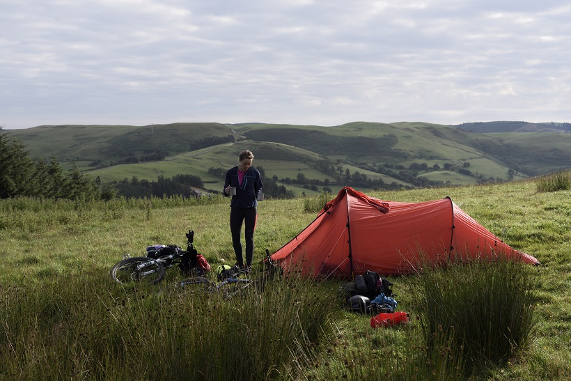
Avoiding the tricky ford over the River Ithon by a short detour we were soon back in open countryside surrounded by green hills. Rather than descend into Rhayader we camped on the hillside above Bwlch-y-Sarnau, leaving us with only a fast descent the next morning to pick-up some more supplies and eat a hearty Ty Morgans breakfast before heading up the Elan Valley.
Onwards and upwards
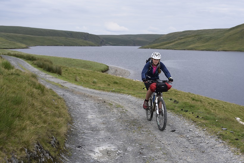
From Elan Village, a steep uphill pedal and short push at one point to gain an undulating track, brought us with a couple of stream crossings, to the foot of the austere and imposing Claerwen Dam. Built to provide water for Birmingham it was completed in 1952. Following the reservoir’s northern shoreline along a stony track for around 10 kilometres this ‘inland sea’ had a sombre feel about it, not helped by a leaden sky.
I wasn’t sorry to leave it behind and reach the Teifi Pools: a group of four lakes at around 1500 feet that in stark contrast were delightful as they sparkled in an extraordinary landscape with obvious evidence of its glaciated past. Stopping for the night near an old farmhouse, marked as Blaen Marchant on the map, it clearly now only served the purpose as shelter for the shepherds when the sheep were being sheared or sorted.
The third day had a lethargy-inducing heat about it from the moment the sun rose above the inversion but it did include the most unusual puncture. Leaning my bike against a fence while opening a gate, a group of inquisitive piglets on the other side of the wire fencing rushed up to sniff the bike, perhaps hoping it was edible, and just to check one of them bit the rear tyre. Luckily the tyre itself was undamaged but the inner tube didn’t survive. After riding past the grey and ochre spoil tips of Cwmystwyth lead mines, the cool of the Esgair Ychion Forest was appreciated. Arriving in Llangurig, reputed to be the highest village in Wales, we headed straight to the Bluebell Inn to slake our thirst. Situated on the A44 this was the first main road we’d seen since Knighton.
Creature comforts quickly eroded our resolve to carry on any further that day and we opted to stay the night at the Glangwy campsite just back down the road. A phone call was made to arrange a taxi to meet us the following day at the finish. To save putting the tent up and ensure a quick get-away we opted for Glangwy’s ‘Welcome Cabin’, effectively a garden shed with a veranda, but it felt luxurious nonetheless. The friendly female farmer who owned the campsite explained how it was now the income from campers that kept the farm going.
In the morning a sinuous thread of single track, only a foot wide, led through the bracken alongside the Afon Bidno, out of the Wye Valley and into the Hafren Forest. The River Severn (Afon Hafren) rises on the slopes of Pumlumon, a few kilometres to the west.
Back on Glyndwr’s Way
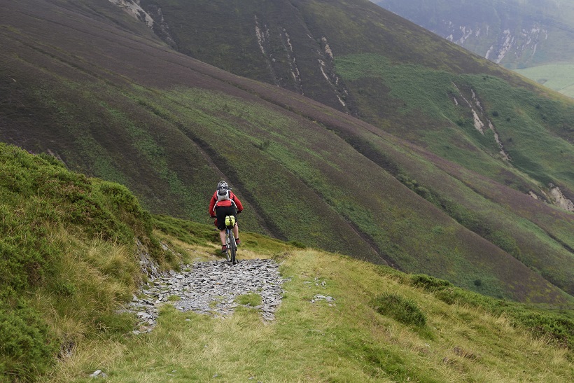
From Staylittle the route re-joins Glyndwr’s Way, over exposed moorland that culminates in a steep but short, shaley descent above a ravine. Not the place to take a tumble. Reaching the lake of Glaslyn we were pleased with our progress, and since Aberdovey now seemed relatively close on the map I made the mistake of thinking we had time to spare as we cooked some soup and took in the impressive scenery below Foel Fadian.
The final descent was actually a long time coming as each downhill section seemed to be followed by yet another climb. The time to meet the taxi was set back for a second time when we missed a difficult to spot turning off a forest track.
Our self-congratulatory mood was tempered on arriving at Dovey Junction Station when we realised there was clearly going to be a problem meeting any taxi. The station didn’t appear to have any vehicular access. The only way to reach this single island platform in the middle of the Dyfi Nature Reserve was along the kilometre long path we’d just ridden from the main road.
Phoning the taxi driver, yet again, solved the puzzle. There had been a misunderstanding and he was waiting at Aberdovey Station, 15 miles away along the coast. I admitted to a none-too-pleased Rachael that the mix-up may have been my fault and I might have said Aberdovey when I meant Dovey Junction. These things happen… don’t they? With a mixture of relief and despair we agreed to meet the taxi in Machynlleth so it was back on the bikes for a few more miles.
But it all ended well as the young taxi driver from Machs Taxis was totally understanding and friendly, he even took us to what he considered the best chip shop in Mach so we could grab some dinner. The £80 for getting both of us and our bikes back to the start in Knighton, an hour-and-a-half drive away, seemed a fair price for the great service and time-saving convenience.
Sitting in the mini-bus I felt that sense of disappointment you get when a great journey comes to an end. Although our last day was the longest in terms of distance, 55 kilometres, it hadn’t felt as hard work as the earlier stages. Perhaps our bodies had begun to adjust to the demands of bikepacking. It seemed that on the route over four days we’d only encountered two walkers, a group of three off-road motorcyclists and one other mountain biker (out for a local ride in the Hafren Forest).
It had been a great journey where you felt immersed in the landscape. Travelling by bike left a greater impression of the rise and fall of the land than you perhaps get from walking, although there were definitely a couple of places I’d like to return to and explore on foot. Next year, expanding my bikepacking experience could be the perfect excuse to go bothying in Scotland.
Words and pictures: Ray Wood.


