It’s the sound of falling rocks we notice first. Somewhere in the vast glacial bowl where we walk, there’s a sudden knock and a clatter. We stop and look around, across the scree and rubble, scanning for the source of the echo. Of course, we can’t pick it out until it moves once more: the confident, patient form of a camoscio. Once it notices us, the camoscio – a chamois in English – shrieks. A strained, high-pitched bark, a sound at odds with the animal’s soft, unostentatious form.
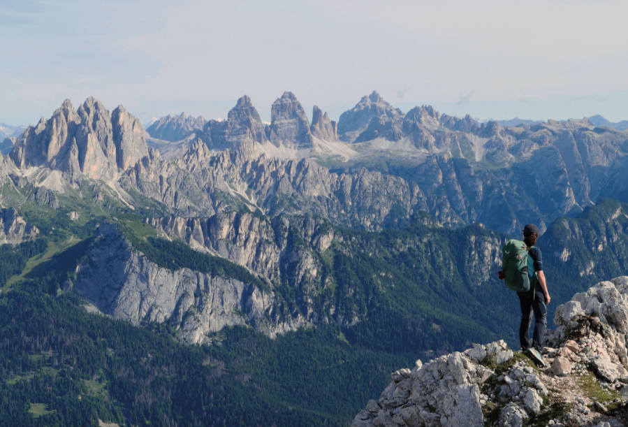
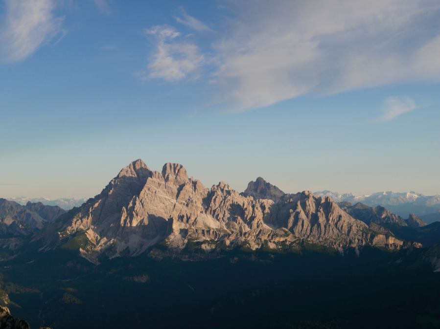
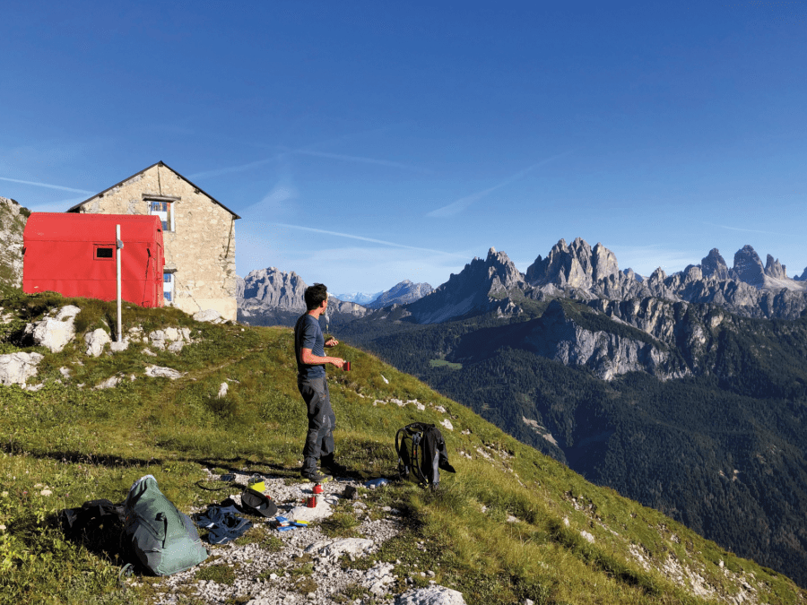
Main image: Views north over the Tre Cime di Lavaredo | Credit: Charlie Jarvis
It shrieks and skips lightly down static streams of broken rock, before turning to watch us move far less certainly among the clutter at our feet. It shrieks once more, as if to mock our unsteadiness, then picks its easy route and skips out of sight among the shards of the mountain.
The hardest of mountains?
We set off into the Marmarole beneath an unfamiliar blue sky. My girlfriend, Giulia, and I have already spent a week in the Italian Dolomites, in sight of these mountains whose summits have been draped in swirling cloud. Today however, the sky is clear and the air cool, and their rough, crumbling peaks stand in the sun, magnificent and daunting.
“The hardest of mountains, without water, without shelter”, wrote Toni Sanmarchi, the first man to plot a route from east to west across this wildest range of the Dolomites, in 1946. Today, the “Strada Sanmarchi” is part of the Alta Via 5, a long-distance route stretching from Val Pusteria on the border with Austria down to Pieve di Cadore. In its entirety, this “high route” is one of the more challenging in the Dolomites. The section we’re taking from Auronzo to San Vito di Cadore – Sanmarchi’s path across the Marmarole – seems impervious, complex, and volatile.
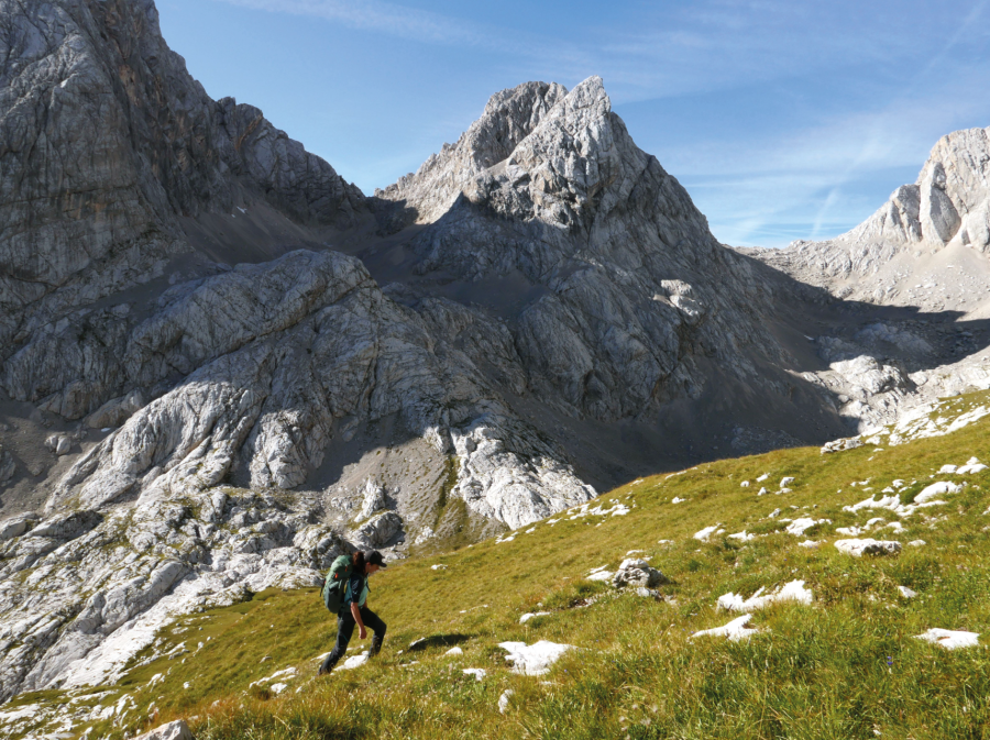
As in the rest of the high Dolomites, to navigate the Marmarole is to pick your way through a landscape in gradual collapse. One walks mainly on scree, in Italian called ghiaione, a word whose sound – to my English ear, at least – perfectly conveys the grind and strain of walking on steep slopes of mobile rock and gravel. Everything we place our feet on slips and dislodges, with potentially dangerous effect. After a thousand metres of ascent, we’ve already crossed the open wounds of two landslides, still fresh and not yet signposted. In the last decade, a bivacco – an Italian mountain shelter – was destroyed here in a landslide. And in 2019, a chunk of mountain smashed into the bedroom of a mountain inn.
As we navigate the debris, it’s apparent why landslides and avalanches are frequent themes in the folklore of the Marmarole. The mythical queen of these mountains is Tana, who rules over creatures with hearts of stone, who have no interest in the concerns of us mere mortals. Yet the human-hearted Tana is moved to protect the local communities by holding back the rocks—at least, the story goes, until her son is killed. After that, she lets the mountains move at their own will, except for one day a year, the “silent day”, when not a single pebble in the Marmarole shifts.
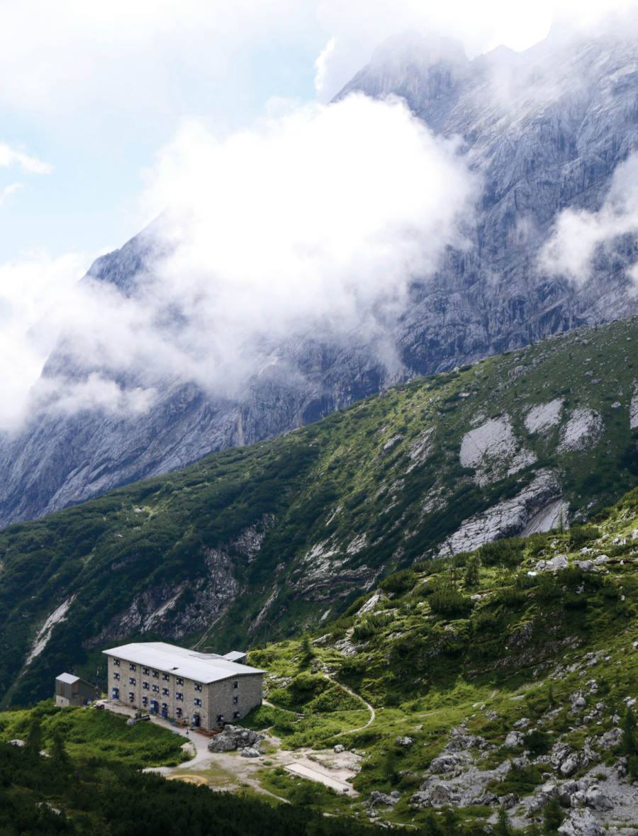
Today, we hope, is that silent day. After three hours from Auronzo, we’ve skirted the southern face of the range, passing the derelict barracks and verdant pastures that are the quintessential features of the Dolomites. Now, we stand at the bottom of a sheer trench of rubble, the Vallon del Froppa, climbing eight hundred metres between bald crags and vertiginous columns. Above us towers the Cimon del Froppa, the highest of the Marmarole, said to be Tana’s ice palace.
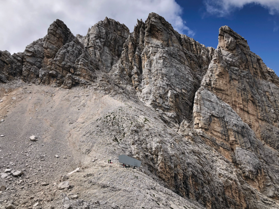
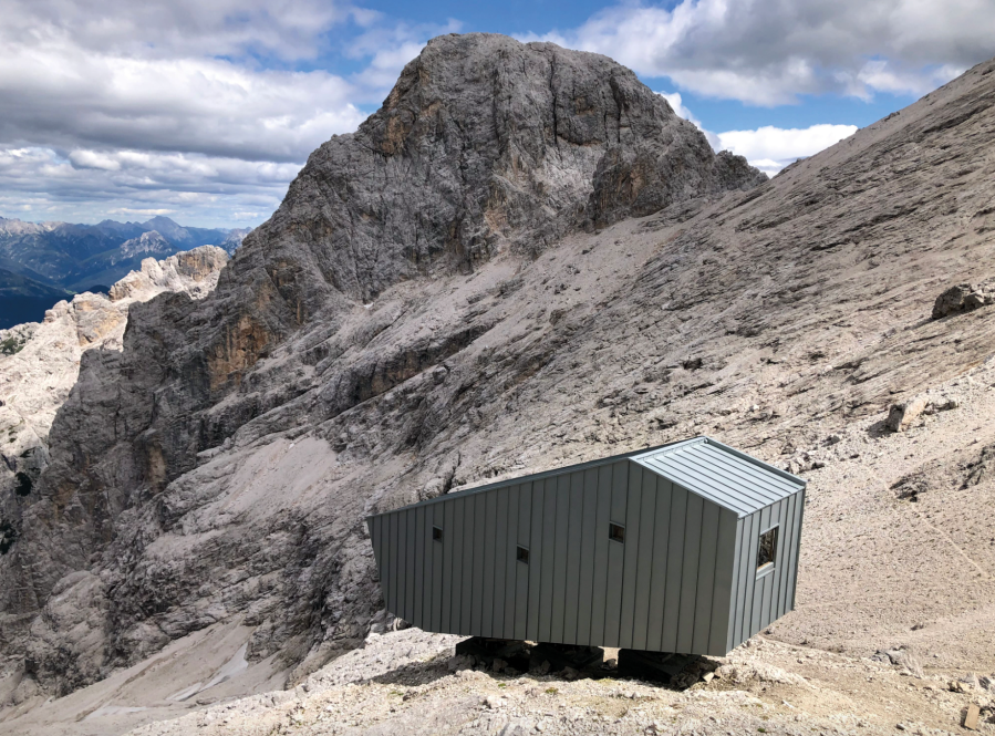
After an hour or more on shifting scree, we pull up and out of the Vallon to the Forcella Marmarole, a small plateau at 2,700 metres above sea level whose views of distant summits are framed by looming cliffs. Rather than an ice palace, we arrive at a new bivacco – Bivacco Fratelli Fanton – a futuristic shipping container of glass and timber helicoptered into place in 2021. It crouches on the rock like a space shuttle, poised for launch. It shouldn’t fit among the myths of ice palaces and grieving mountain queens, but someone it only adds to the otherness and mystery of these mountains. We make our bed, eat, and wander among the shelves, troughs, and buttresses that surround the space age refuge, as light snowflakes fall and vanish before landing.
In the footsteps of the camosci
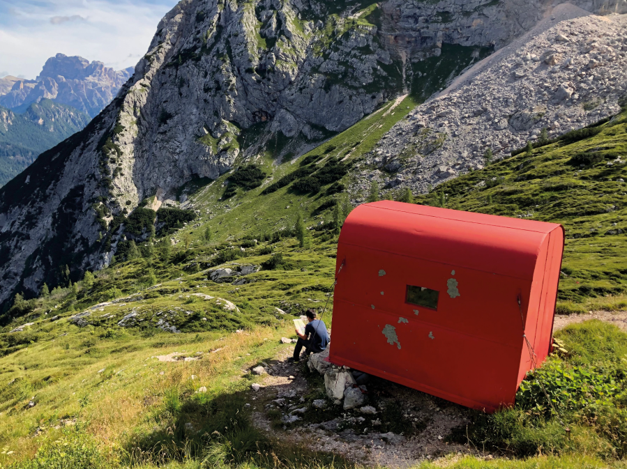
“When I came thirty years ago, I met no one, not a soul. In the evenings, I’d sit by the bivacco and watch the camosci come down into the valley to graze.”
We’ve just arrived at Bivacco Musatti, a red tin shelter in a vast grass-softened bowl. We’d awoken to a splendid dawn that washed the famous peaks of the Dolomites in pink: Monte Cristallo and the Cadini di Misurina to the north, Antelao and Sorapis to the west. Their shapely forms stayed in sight all morning, as we crossed the pits of scree and the slanting slabs of rock to arrive at a place that we’d heard lots about. Giulia’s dad, a mountaineer who passed on his love of the Dolomites to his daughter, had stayed at Musatti three decades prior. We sit down to rest and eat with his remembrances ringing in our ears.
“Water’s hard to find, if there’s any at all. Some sections of the path are seriously exposed, and the going is exhausting. There are few places in the Dolomites where you’ll feel so completely alone.”
Not all encouraging words. But there was something inspiring in these stories of the Marmarole: the physical challenge, the strange, beguiling harshness of the landscape, the close and solitary encounters with the native goat-antelope.
Whoever has walked through these mountains is not so much in Tana’s domain, but in the kingdom of the camoscio. The beast is a common enough sight across the Alps, but here, you literally follow their paths. In the nineteenth century, it was local hunters who first ventured here – including Cimon del Froppa and Antelao – before the “mountaineers” came to hire their expertise. And without the camosci there would be no Strada Sanmarchi at all.
Sanmarchi himself was honest about where the real credit lies for finding his route. “We let ourselves be led by the camosci, to discover where these four-footed acrobats would pass,” he wrote. One story tells of how, after many attempts to traverse one of the most exposed sections of the route, he put his trust in the only creatures that really knew this place. Each thin shelf he had so far tried eventually fell away into empty space. But as he followed the animals at a distance, they led him on the route that took him to safety.
“In its journeys for food or love, the camosci follow routes that may not be the shortest or the easiest, but they’re always the most logical”, he wrote. It’s a great image, a perfect admission that we have much to learn about these high and hostile places. Up here, we’re all guests, walking in the footsteps of those who know so much better.

Dust, ice, and water
We leave Musatti, a scruffy meadow littered with erratics and flowers, to climb once more into the desolate zones above. Following Sanmarchi’s path is to yo-yo between meadow and grey desert, down then up once more, totting up thousands of metres of up and down that you feel in legs and lungs.
That’s largely due to the glaciers that once defined the Marmarole, but that are no longer here at all. The name Marmarole is thought to come from an old Greek word, marmar, meaning “to shine or sparkle”. As many as five glaciers once glistened here. In photos from a century ago, when Sanmarchi first walked this way, you can see their magnificent and tatty girth. Today, the map names just one. In the twenty-first century, alpine glaciers are melting at a faster rate than ever. It’s hard not to feel their loss.
Where ice once settled, only round and steep-sided gouges remain, ice cream scoops in the mountain. We pass through the deep imprint of a now-absent glacier, and up over the Forcella Croda Rotta—the Pass of the Broken Rock, a name that could describe almost anywhere in this range.
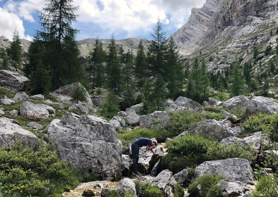
“Listen. Can you hear it?”
Giulia interrupts my thoughts and the unsteady crunch of our footsteps on scree. From Croda Rotta, we’ve descended the precipitous Forcella Vanedel, a gulf between cliffs overlooking the valley floor a thousand metres below and rounded a flank of mountain. After two days in the high, arid land, we’re in a valley with trees and, somewhere, the giggle of a stream. We rush towards the sound, strip off our dusty shoes, wash and drink without fear that we’ll need to conserve water for later.
Our thirst quenched, we look up. The red box of Bivacco Voltolina looms like a sentry over the valley. On the map, fallen boulders look like biscuit crumbs on the valley floor, but up close, each crumb is the size of a house or a car. Among them, Voltolina is our resting place for the night. We unpack, spread out across the rocks and as the frigid clouds close in, put on every layer we have.
Path of Peace
Sanmarchi planned the route that now bears his name as a path of peace. In a gesture of reconciliation, he traced this itinerary along Italy’s northern border that was a frontline in the First World War. Among these stones, Italians and Austrians had shivered and fought, attempting to detonate mountains to dislodge the enemy and control the terrain. It was a violent, shameful blip in a landscape that refuses to belong to anyone.
After a cup of tea, I leave Giulia to her book and climb into the upper reaches of the valley. Above the bivacco, it opens up into a broad coire, surrounded by crumbling peaks that are now rarely explored: Cima Scotter, Cima Bel Prà, Cime Bastioni. But in the cleft of one of high ridges, I find a trace from a previous century. There are rocks decorated with images of camosci, presumably to mark a hunting path.
Hunger gets the better of me and I turn back down to Voltolina. There once more is the knock and clatter of falling rock – and the now familiar shriek of a camoscio. High above me on the shelf of the Cime Bastioni, there are fifteen or maybe twenty of them, quick and agile among the unforgiving shelves of the mountain.
Marmarole: the wild side of the Dolomites
Although known for their relative remoteness, the Marmarole are actually quite accessible. Cortina d’Ampezzo, the historic town co-hosting the 2026 Winter Olympics, is just 10 km away. Villages like Auronzo or San Vito di Cadore are all easily reached from major airports (such as Venice, Milan, and Bologna).
The new Bivacco Fratelli Fanton from Val de Rin, just outside Auronzo is accessible in a day, albeit one of 1500metres of ascent. Alternatively, walk beneath the peaks of the Marmarole in the Val d’Oten, along a path which takes you up to Rifugio Galassi, an ex-garrison close to Antelao, the mighty “King of the Dolomites”. Another great day hike takes you to the Rifugio Antelao, built by Giovanna Zangrandi, a partisan who lived in the Marmarole during the Second World War. From here, you get a view of the whole range.
The Strada Sanmarchi technically runs between Bivacco Musatti and Bivacco Voltolina, but you can extend it, as Charlie did. Alternatively, follow it as part of the larger Alta Via 5, running from Sesto in Val Pusteria to Pieve di Cadore. It’s an 80-kilometre route in eight sections, much of it requiring via ferrata kit. You’ll be able to find shelter in the rifugi or mountain huts along the way, but it’s best to book in advance.
Hike Charlie’s extended version of the Strada Sanmarchi
Start: Auronzo di Cadore (Province of Belluno [BL], Veneto)
Finish: San Vito di Cadore (BL, Veneto)
Day 1: Auronzo to Bivacco Fratelli Fanton
- Distance: 15 km / 9.3 miles
- Ascent: 2,100m / 6,900 ft
- Descent: 650m / 2,130 ft
- Time: 6 hours
Day 2: Bivacco Fanton to Bivacco Voltolina
- Distance: 14 km / 8.7 miles
- Ascent: 1,700m / 5,580ft
- Descent: 2,250m / 7,380ft
- Time: 9 hours
Day 3: Bivacco Voltolina to San Vito di Cadore
- Distance: 13.5 km / 8.4 miles
- Ascent: 550m / 1,800ft
- Descent: 1,800m / 5,900ft
- Time: 4 hours
This feature was first published in the July 2024 issue of The Great Outdoors.